Pittsburgh, Pennsylvania
2020
Commissioned by the Three Rivers Arts Festival, a production of the Pittsburgh Cultural Trust
-

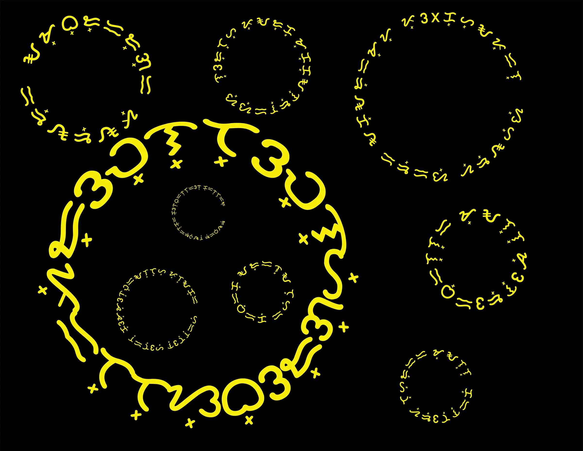
Risk Map (mask): May 1 - 7, 2020
by Edith Abeyta
Measuring air quality is complicated. Reporting the results is equally complicated. The Environmental Protection Agency (EPA) has standards or rules to measure the amount of particulate matter (PM) in the air and if levels of PM 2.5 are safe. To determine the air quality index (AQI) for any given day, hourly readings are averaged for 24 hours. This number should be equal to or less than 35 micrograms per cubic meter. The annual standard for PM 2.5 is 12 or less micrograms per cubic meter. This is also an average. These numbers are required to be met to be in compliance with the EPA.
These regulations do not illustrate the real time effects of AQI. They represent what has happened but do not indicate what is happening or what will happen. Using daily and annual measurements, decisions cannot be made to protect one's health. For example, where I live, 1/2 mile away from a major source polluter, it is possible to be in compliance for the day, but have large spikes in AQI throughout the same 24 hour period. This regularly occurs - spikes in air quality that sometimes exceed 150 and regularly over 100 multiple times a day. Long term exposure to unhealthy air is a threat to one's health which includes heightened susceptibility to viruses.
How does one translate these measurements in the interest of public health? Risk Map (mask): May 1-7, 2020 is an attempt to identify a visual pattern for prediction using the AQI colors which represent the level of safety. The color key is included on the map. There are seven segments each representing a day starting with May 1 and moving to the right that are divided into 24 blocks. Each of these blocks reflect the AQI index recorded on my own purple air monitor for one hour starting at midnight and moving left to right and top to bottom with the last block representing the AQI for 11:00 - 11:59pm. It is the intention of this map to be used in conjunction with other weekly risk maps so that hourly, daily, monthly, weekly and annual predictions can be made for future assessments about when it is safest to go outside or open windows.
-

A Historic Bike Tour of Radicals and Subversives in and around Downtown Pittsburgh
by Eric Boerer
The map provides a brief tour of select sites important to the struggle for social justice and worker rights in and around downtown Pittsburgh. On the tour, you'll learn about Jewish immigrant stogie workers fighting for safe conditions, radical Abolitionists against slavery, an escape attempt from Western Penitentiary, as well as other organizing efforts, resistance, and nefarious plots. The seven stops over 12 miles are meant to be taken at your own pace, and there is no need to do the tour in order, it just makes for a pleasant bike ride. Some of the places on the tour no longer exist, but being on location allows you to imagine what it was like to live through these tumultuous times.
Originally accompanying the tour was a zine, or homemade magazine, assembled with images taken from newspapers, library archives, and the Pittsburgh Bike Map, in the traditional cut and paste style that was popular in the pre-home computer era of the copy machine.
I’ve scanned the pages of the original map and zine and presented them online along with the text to make it easy to read and follow along: https://pghradhistorytour.wordpress.com/. You can also view and download a gpx file of the route https://ridewithgps.com/routes/32665330
-

Place and Time
by Nick Childers
This digital collage is a representation of how we navigate our memories from particular spaces in time that perpetually exist, challenging the notion that time is linear and only going one way. Using photographs that the artist took around the Pittsburgh area as various "planes" of time/space and satellite images of Pittsburgh from Google maps, this piece invites the viewer to explore the concept of the multiverse. The photograph of space in the background taken from the NASA international space station represents how limitless time/space really is while the map of Pittsburgh from 1890 serves as a reminder that we are still stuck in the physical realm. The images chosen are from particular scenes around Pittsburgh the artist photographed that he considered special moments that provide a glimpse into the metaphysical world.
-
Mapping the Portals of Her Spirit
by Veronica Corpuz
The word baybayin means “to write” or “to spell” in Tagalog. Baybayin refers to several indigenous scripts in the Philippines and is an alphabet or more precisely a syllabary of the pre-colonial writing system that still lives today. By deciphering the script, audiences are invited to visit the places in Pittsburgh where poet and artist Veronica Corpuz performed in her youth traditional folk dances of the Philippines.
-

After Traveling Half of the Globe
by Tuhin Das
I came to Pittsburgh to express myself freely. With this map, I am sharing how I see Pittsburgh’s neighborhoods and where I have been invited to use my voice and share my story.
-

Strange sound became a spiral
by Christiane Dolores
In September of 2011, I heard a strange sound emanating from the sky that shook the windows. It made my hair stand up and my gut clench; it felt like it shook the core of me. Researching, I then found videos people had made all over the world with the exact same unexplained sound. A few nights later, 2 am, I found myself driving in a spiral as far as Cranberry to Duquesne, visiting all the places I have lived, driving past friend's houses, places where an important event in my life took place. The whole drive took several hours and I saw the sun rise. The history of me in a place etched in land, traveled via roads.
-

Finding LOVE in Pittsburgh
by Fran Flaherty
Pittsburgh Love Stories: A remix of an 1855 JH Colton Map of Pittsburgh, updated to reflect some of the changes in Pittsburgh Streets. Each location with a red LOVE image marks a story where someone found LOVE in Pittsburgh. Anecdotes of these stories are in the PDF version of the map. Its physical location will have an inconspicuously placed 3d printed LOVE sculpture that will be available to keep by whomever finds it.
-

Mapping My Heart
by Sherrie Flick
My map explores the metaphorical resuscitating, planting, and transplanting of my heart via two gardens in the South Side Slopes of Pittsburgh.
-

Pittsburgh National Park
by Toby Fraley
An exact 1:1 scale overlay of Yellowstone National Park on top of Downtown Pittsburgh.
-

A Hydrological Survey of Girty's Run
by Steve Gurysh
This is a psychogeographic poem of Pittsburgh's three river system and is intended as a tool for exploring and expanding one's connection to the Allegheny, Monongahela and Ohio Rivers and their intertwining histories.
-

Northside Notation No.01 by Yona Harvey
by Yona Harvey
This map is a visual poem of my favorite corner in Pittsburgh's Northside neighborhood. It is also an homage to poet and Pittsburgh native son, Joel Dias Porter, inventor of "Landscape Poems" and inspiration for this work.
-

Rainbow Roads: Allegheny County’s Color Belts
by Jeffrey Krsul
Toned cyanotype with gouache collaged on screen print and cyanotype.
Depicting Allegheny County’s color-coded “belts”, which were developed in the late 1940s by Joseph White, an engineer with the Allegheny County Department of Public Works, as a wayfarer system using a network of federal, state, and municipal roads to offer residents alternative traffic patterns which did not lead to downtown Pittsburgh's congested Golden Triangle. The City of Pittsburgh developed a Purple Belt for the downtown area during the mid-1990s using the county system as a guideline.
The underlying patterns were created by enlarging security envelope patterns that resembled topographical maps, and then printed in cyanotype (and toned in ammonia) as well as screen printed.
-

Pittsburgh con Arte
by Carolina Loyola-Garcia
In an imaginary Pittsburgh, there is free college education, free health care, plenty of Tablaos (taverns to enjoy food and live flamenco music and dance), immersive plant stores where you can take naps, beaches on the shore of a flowing and clean river, a subway system to move across the city as well as car2go stations, plenty of museums, art galleries, parks, and food. In this town, people speak multiple languages and are driven by curiosity and a passion for learning and experimentation.
-

Fairywood: What happened to the fairies?
by Marcè Nixon-Washington
This map displays photographs of the historical community of Fairywood, located at the most western part of the city of Pittsburgh. Fairywood, as we know it today is referred to as a "ghost town" as it is filled with several abandoned lots, industrialized buildings and a few blocks of houses. This map retrieves the slowly forgotten history, of times people filled the streets, occupied buildings and communities like Westgate Village and Broadhead Manor. I have the privilege of carrying the narrative of some of the forgotten people, who once resided on the land from the mid 1900's to the early 2000's. The history of Fairywood is a long complex story of tension, abandonment and gentrification. It is a narrative, upon reflection brings tears to many peoples eyes. It brings up the question: How can we respect, revitalize and stabilize communities, while cherishing the history, the heritage and the people?
Read Marce’s poem What happened to the fairies in the woods? A Narrative of the forgotten neighborhood, Fairywood.
-

Cry Me Three Rivers
by Renee Piechocki
You have to feel your feelings. Sometimes you can be out for a walk having a perfectly fine evening and the weight of the times gets caught as a lump in your throat. The many reasons we shed tears are currently compounded by a global pandemic, a stomach-churning political landscape, and seeing neighbors and families suffer. There is nothing wrong with crying anywhere you please, but sometimes you just want to be alone. And you don’t always have time to make it home, and what happens when it’s home making you cry? This map of field-tested places Downtown is offered as an act of friendship, a community service for those situations. No space for tears of joy is listed. If you have those, please share them everywhere you can. Let’s hope they are contagious.
-

Talbot Towers
by Curtis Reaves
These two maps illustrate where Talbot Towers was located in Braddock, PA. Talbot Towers was a 210-unit housing project built in the 1950’s, and it was demolished in the early 1990’s. My parents Alberta and Eugene Reaves owned Bert’s Market. The market was named after my mother, as everyone called her Bert. Conveniently located across from Talbot Towers, building-C, Bert’s Market provided needed essentials as well as jobs for many community youth for nearly 40 yrs. Upon touring the Braddock area, my hope is that visitors can appreciate the value and rich history of the Braddock community.
-

Under the Same Sky
by Diane Samuels and a poem by Chenjerai Hove
My map is a vehicle to hold Chenjerai Hove’s poem, Sky. Chenjerai Hove (1956-2015) is a poet from Zimbabwe who was in exile in Stavanger, Norway and Miami, Florida through the International Cities of Refuge Network. I met him at a conference in Barcelona, Spain in the spring of 2009 and he remotely joined City of Asylum’s Jazz Poetry Concert in the fall of 2009 and read Sky.
The poem moved me deeply and continues to do so, especially during the current difficult times.
To make the piece, I cut a map of the world in half, turned one half upside down, cut each half into strips and wove the two parts together. Then, using a Rapidograph pen, I hand transcribed Chenjerai Hove’s poem Sky onto the woven map. His poem is written on the North Pacific Ocean woven together with the Bering Sea and the Sea of Okhotsk.
We in Western Pennsylvania are woven together with Southern Mongolia. Examples of other areas woven together are Sudan and the Faroe Islands & Scotland; Venezuela and Russia; Turkey and the North Atlantic; Ethiopia and Iceland; Bangladesh and Eastern Canada. These pairings are the unplanned result of the weaving.
There are two sides to the piece –Day Sky and Night Sky. For Night Sky, I inverted the map (created a negative image) in PhotoShop so that the woven together country names and shapes would look like stars in the sky that Chenjerai Hove describes.
References
Chenjerai Hove: icorn.org/writer/chenjerai-hove
The book containing Sky: “Blind Moon,” Weaver Press, Harare, 2003
-

Simon Map
by James Simon
The Simon Map shows the various public art installations James Simon has created in the region since he opened his studio in Pittsburgh In the early 2000s.
Fefe his cat will take you on a walking tour.
-

The Land that Held the Lenape Settlement of Shannopintown
by Shaun Slifer
Before settlers came to what we now call Pittsburgh, before the onslaught of the war between the French and British over colonial control of the forks of the Ohio River, this land was occupied at different times by Hopewell, Monongahela, Osage, and Shawnee peoples, and most expansively/recently by the Haudenosaunee.
Shannopintown, or Shannopin's Town, was the last recorded Indigenous settlement within the borders of what is now the city of Pittsburgh. Because of the violence inherent in settler colonialism, by the time Shannopintown was first recorded, many of the Lenape were already in movement away from their ancestral homes in the east. Modern attempts to pinpoint the exact location of Shannopintown by regional historians are based on settler journals, early maps, and a burial site which was uncovered during building excavations in 1862. The written and archived historical record revolved entirely around interactions white settlers and soldiers had with people living in the village.
This map illustrates 260 years of land use and memory, reflecting my own experiences with trying to contextualize the history of one small space, a few city blocks which have held so much that can no longer be seen.
-

Pittsburgh Bookstores
by Sara Tang
Explore Pittsburgh's independent bookstores in different neighborhoods around the city! This map blends old freehand drawing by eye from viewing Google maps. While viewing these book shops in Google Maps, I was struck by how prominent highways are in our modern era. I did not include the names or numbers of the highways in my map. I was reminded of blood arteries and brain synapses, connecting life sustenance, oxygen, and thought itself through channels beneath our skin. I would invite fellow book lovers to explore and support local bookshops as a way of honoring the treasures of knowledge and story that connect us all.
Please note that this map is not exact in its depiction of distance. Libraries, the many comic book shops of Pittsburgh, and University book shops are not included.